Only relics, rusting pieces of steel, and the rare preserved object remain of the great interurban railway that once connected the cities and towns of the Tri-State area. While we intend to go much further into depth on the railway, for now we’re going to provide a glimpse of it. Below is a map from 1911 showing the steel web of connections of the Southwest Missouri Railway.
An article from the Joplin News Herald proudly boasted that the railway was one of the first of its kind, beginning service in 1893 with a 10 mile long connection between Joplin, Cartersville, Webb City and Prosperity. Nearly two decades later, the railway had accumulated 75 miles of track and was accessible to over a 100,000 residents of the area. In 1894, the railway was used by 400,000 travelers, a number that grew to an astronomical 8,000,000 by 1910.
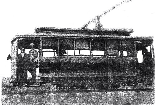
Initially served by small cars, like the one pictured below, by 1911, larger trolleys were in service powered by four 50 horsepower engines. Cars ran every half hour between the towns with the exception of Joplin to Carterville, 15 minutes, and Joplin to Webb City, every 10 minutes. The costs ran anywhere from 1 penny to 1 1/2 cents per mile. A very low and reasonable rate, the article in the News Herald added.
Source: Joplin News Herald, 1911


Have you come across any maps that show the trolley routes within the city?
Unfortunately, at this time we haven’t uncovered one. Doesn’t mean one isn’t out there to be discovered!
I have one of the trolley’s that came from Joplin, it was turned into a diner , you can still see the sign on the side that reads Chicken Dinner 25 Cents.
I’m trying to find out which one it was, It looks like the above picture of the #3 trolley.
Where can I go to find out which trolley went where, I want to do some research.
Back in the ’50s, the culverts and rail paths between Croweburg and Mulberry were still visable. I assume they were swallowed up by the earth years ago. My Dad, who was a coal mining teenager in the 1910’s, told me the last Saturday night trolley leaving Pittsburg for Mulberry was always so jammed that people had to hang off the sides.